The wall
Trollstigen, Geirangerfjord, Strynefjellet and Loen, then back through the UNESCO fjord and over Trollstigen a second time. A 5-day, 4-night camping loop through the heart of Western Norway, on two wheels.
Five places stitched into a single round trip from Åndalsnes: Trollveggen and Trollstigen, down to Valldal, the Linge–Eidsdal ferry, up Ørnevegen to Geiranger, over Strynefjellet to Loen, and back via Stryn and Hellesylt through the UNESCO Geirangerfjord. The loop is roughly 290 km with around 3 200 m of climbing across five days, sleeping in a tent each night. Counterclockwise is the right direction – it puts the brutal Åndalsnes side of Trollstigen on fresh legs at day 1, and the gentler Valldal side as the final climb on day 5.
The ferries are what make a true round trip possible without backtracking the whole mountain section. Linge–Eidsdal runs every 30 minutes and is barely a planning constraint. The Hellesylt–Geiranger crossing is the one to time and book – four sailings a day through the fjord, with the last from Hellesylt typically around 17:30. Plan day 4 around it and the rest of the loop follows naturally.
Late June to mid-August is the realistic window: Trollstigen reliably open, Strynefjellet clear, ferries on full summer schedules. Early June can still hit snow patches at Djupvasshytta. After mid-September the Geiranger–Trollstigen Scenic Route starts closing for the season.
A gravel bike or sturdy road bike with 32–35 mm tyres handles every paved section comfortably. Gravel is better if you want the Dalsnibba spur (5 km gravel toll road to 1 500 m). Pack a real shell and a warm layer for the plateau crossings – sub-10°C in July is normal up high. Bring a small chain repair kit; the nearest bike shop on route is in Stryn.
Start and finish at Åndalsnes. The Raumabanen train from Oslo carries bikes (book a bike slot ahead). From Trondheim, take the bus or drive to Dombås and connect to Raumabanen, or ride the coastal road in. Nearest airports are Molde (~60 km) and Ålesund (~120 km), both with bus connections.
Established campsites every night cost ~200–300 NOK and have kitchens, showers and shelter from weather. Allemannsretten – Norway's right-to-roam – covers the whole route if you'd rather wild-camp away from buildings. For ferries, only Hellesylt–Geiranger needs booking in July/August (book bike spot at fjord1.no).
Tap a day pill to swap the summary card and filter the map pins. The whole route stays visible as a dotted line. Tap "All days" to see the full loop at once.
Counterclockwise from Åndalsnes. Distances are nominal – give yourself buffer for ferries, photos and weather. The hardest day is stage 3 over Strynefjellet; the easiest is stage 2, which leaves an afternoon for Geiranger.
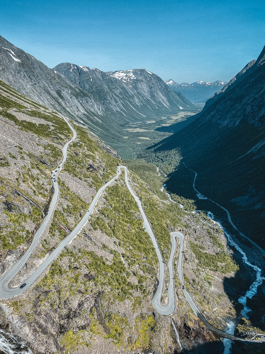
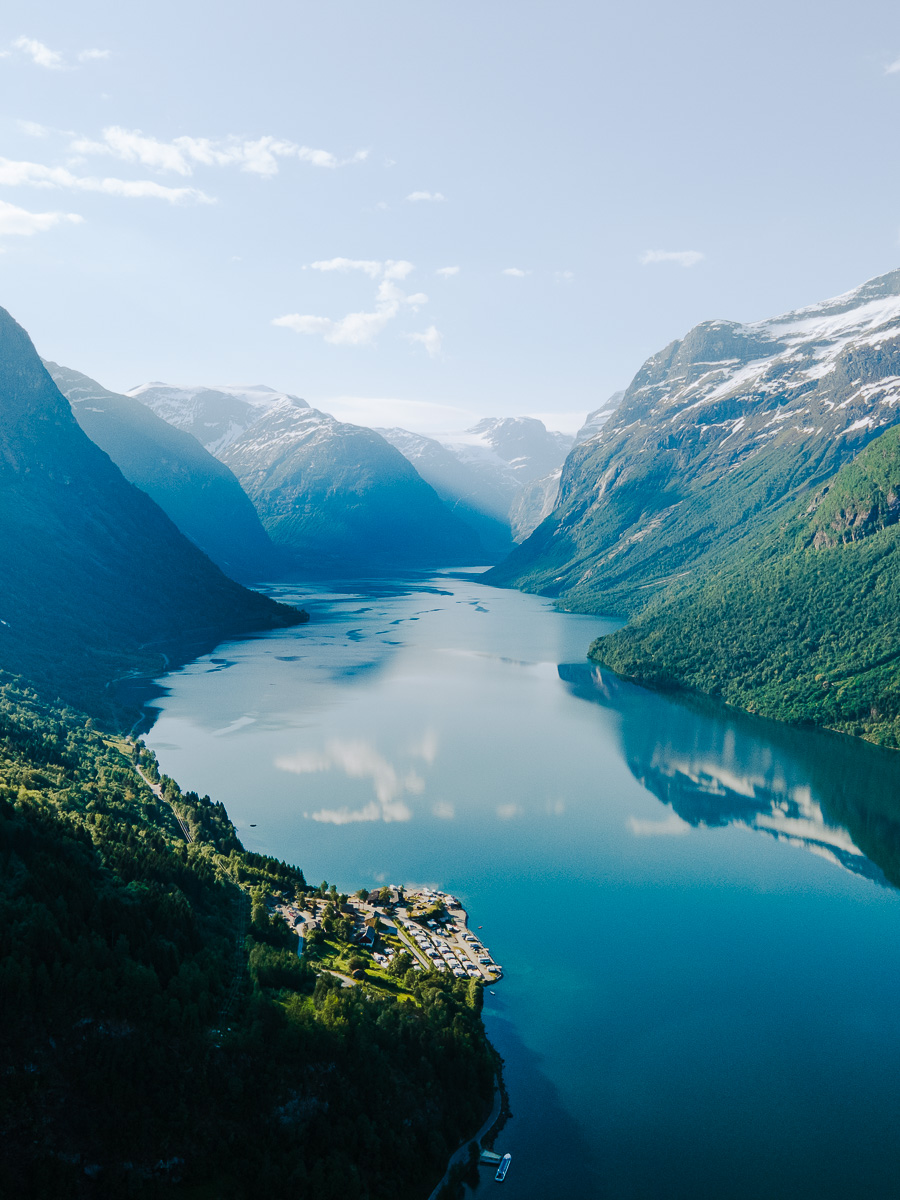
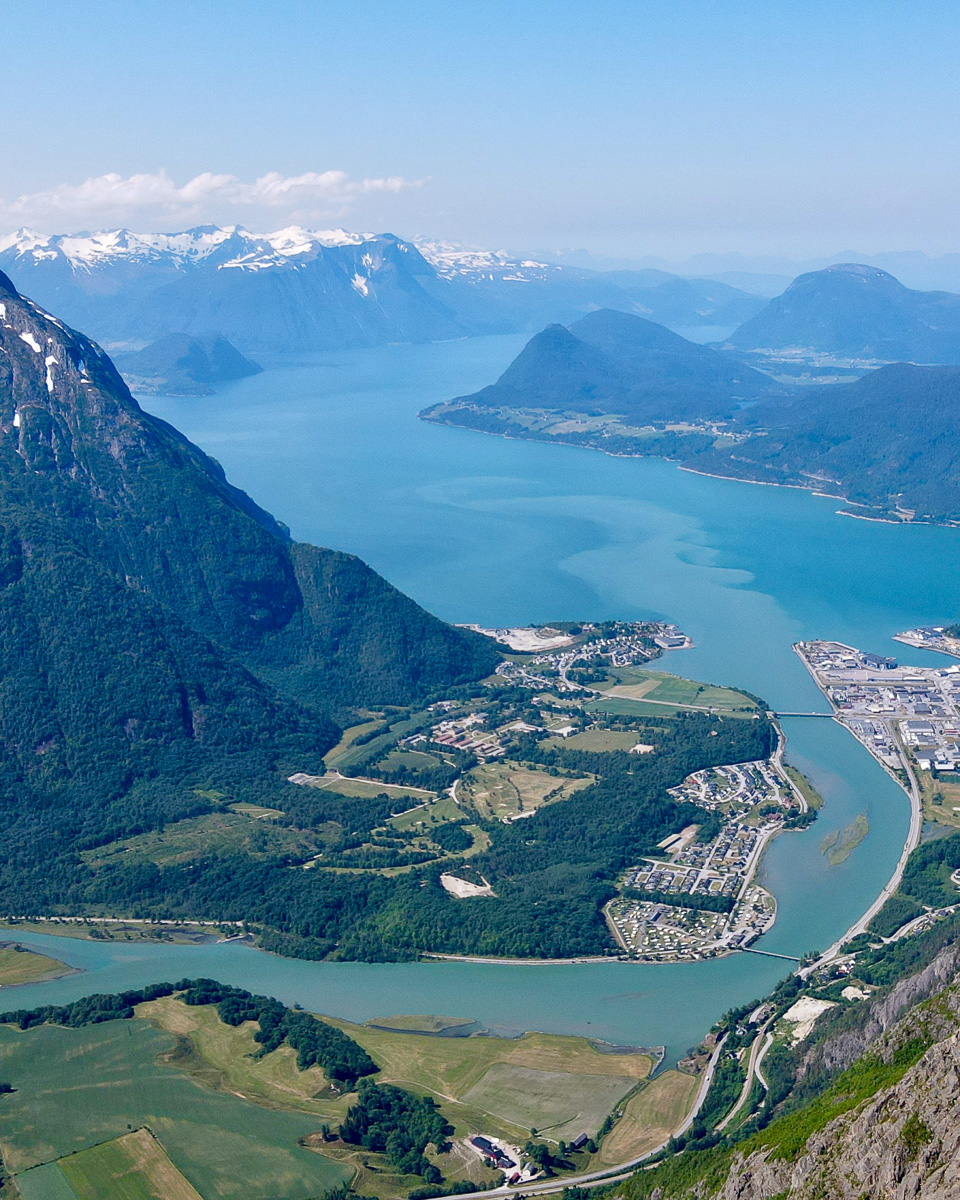
Roll south down Romsdalen along the Rauma river, stop at Trollveggen Besøkssenter for coffee and a look up at Europe's tallest vertical rock face, then turn into Isterdalen at Sogge for the climb. Eleven hairpins up the Åndalsnes side of Trollstigen on fresh legs – the spectacular side, no argument. From the plateau (850 m) it's a long descent through Langfjelldalen to the strawberry valley of Valldal.
Five flat km to Linge, ferry across to Eidsdal (13 min, no booking), then the famous Eagle's Road climb over Korsmyra and down into Geiranger. A short day on purpose – arrive by early afternoon and you have time for Flydalsjuvet, Storseterfossen, or just the fjord. The descent into Geiranger from the south rim is one of the great cycling views in Norway.
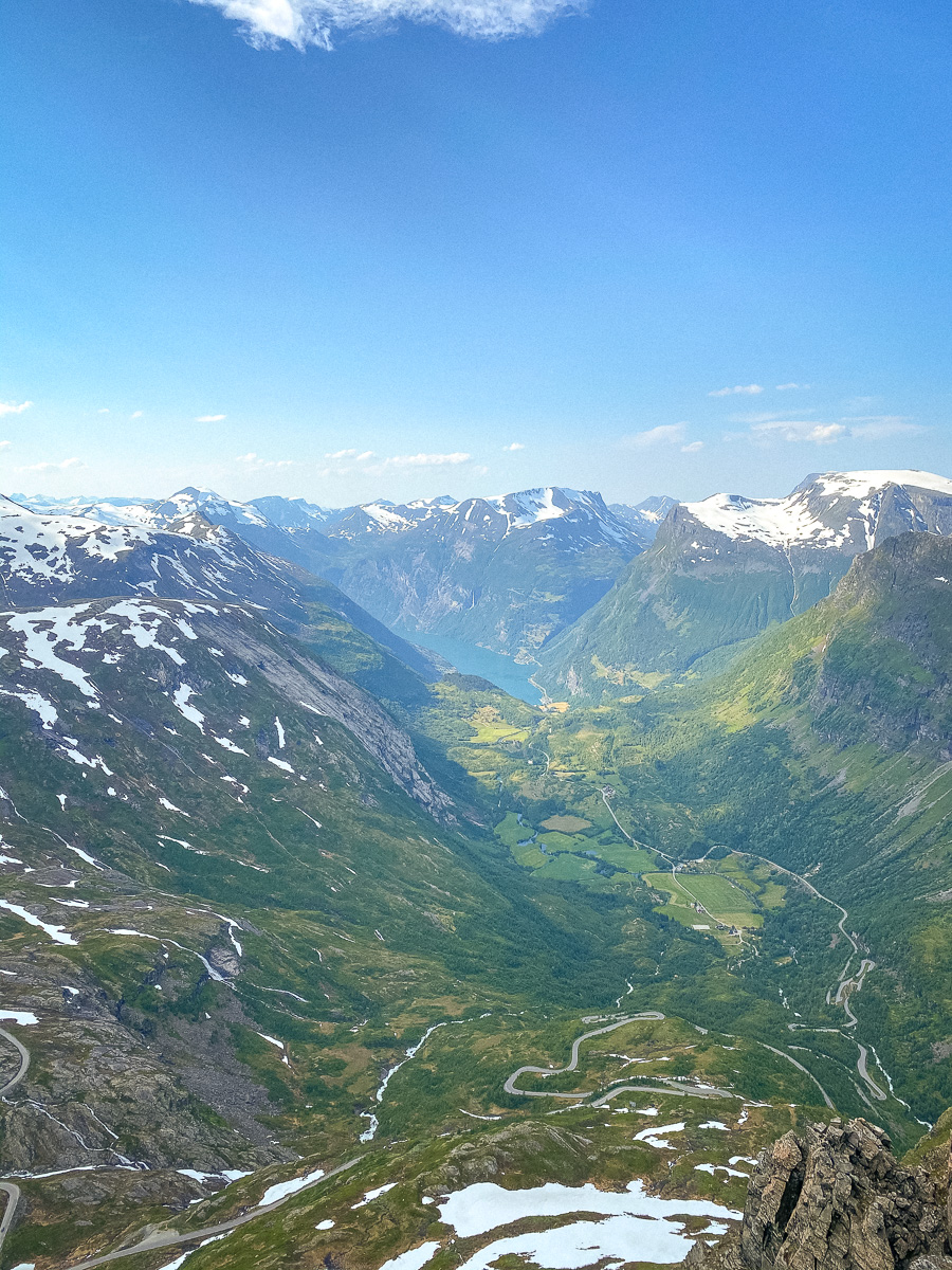
The big day. Climb out of Geiranger to Djupvasshytta at 1 040 m, with the optional 5 km gravel spur up to Dalsnibba (1 500 m) for those with legs left. Then the old Strynefjellsvegen drops you through hairpins to Hjelle and Oppstryn, with the descent into Loen along Lovatnet one of the great rewards of the trip. Treat this day with respect – pack lunch, lots of water, and ride to the cloud rather than the clock.
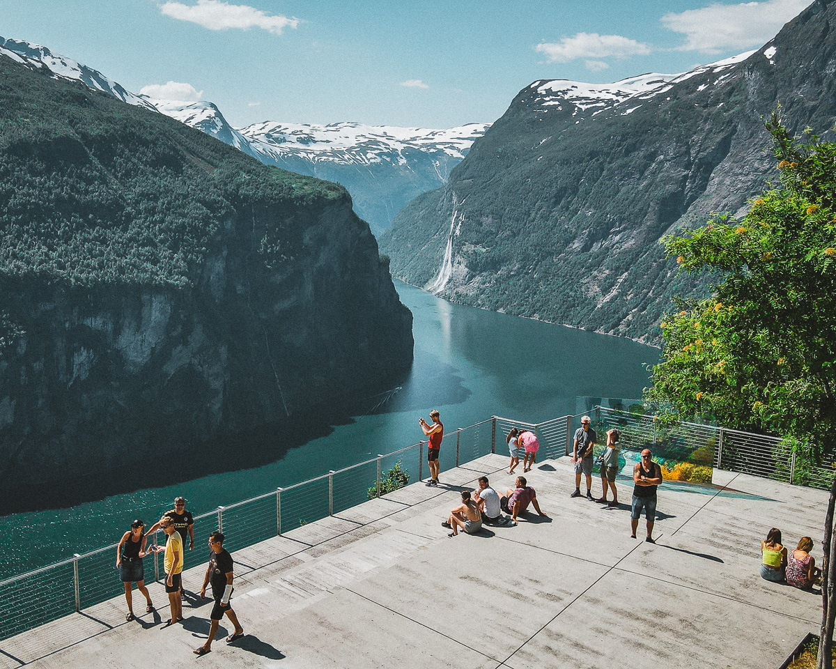
Drop down from Sande Camping to Loen, roll along Innvikfjorden to Stryn (resupply at Rema 1000 in Stryn Torg), then climb Hornindalseidet to Hellesylt. The pass tops out around 250 m – not bad with fresh legs. Catch the afternoon ferry through Geirangerfjord – the UNESCO crossing, 65 minutes past the Seven Sisters and the Bridal Veil. Last sailing typically around 17:30; aim to be at the quay by 16:00.
Descend Ørnevegen – your stage 2 climb in reverse, much more enjoyable downhill – to Eidsdal. Ferry across, ride through Valldal, then climb back over Trollstigen from the south. The Valldal side is longer but gentler than the Åndalsnes hairpins, which is the right note to end on. The 11 hairpins are now the descent, and they finish you in Romsdalen with the train home in sight.
What to expect at the top of each. The first is the iconic photograph; the second is the most cinematic descent of the trip; the third is the longest and most committing.
From Trollstigen Camping at the foot of Isterdalen, you can already see the road switchbacking up the cliff above the Stigfossen waterfall. The climb itself is short by Alpine standards but visually relentless – eleven numbered hairpins, sustained 9–10% gradient, and the waterfall thundering past you for the whole upper half. Plateau cafe and viewing platforms at the top. Cold and windy even in July; bring a layer for the descent.
From Eidsdal the road climbs steadily up Korsmyra, then drops down the south side in a series of sweeping switchbacks with Geirangerfjord opening up in front of you. The descent into Geiranger is one of the great cycling views in Norway, and the climb back up it on stage 5 is shorter than it looks. Watch for tour coaches; ride defensively in the descent.
The longest and most committing climb on the loop. Geiranger to Djupvasshytta gains about 1 000 m over 17 km, with the old mountain road dropping you down through hairpins to Videsæter and Hjelle. Cold above 800 m even in July. From Djupvasshytta, the 5 km gravel spur up to Dalsnibba tops out at 1 500 m with one of the great Geirangerfjord views – worth it if your legs are still talking to you.
Three ferry crossings, four campsite nights, and one mountain road you should check the morning you ride it. Here's what each looks like.
Fjord1 route 1054. Departures every 30 minutes from 06:15 to around 22:45 in summer, ~13 minutes across. Walk-on with the bike, pay by card on board. No booking needed even in high season.
The crossing that closes the loop. Only 4 sailings a day, the last from Hellesylt typically around 17:30. Past the Seven Sisters and Bridal Veil waterfalls, with classic ferries Skånevik and Røsund covering the route until the new electric ferries arrive. In July and August book a bike spot ahead, especially when cruise ships are docked. Expect around 150 NOK per cyclist.
Ferries total around 250 NOK with the bike across the three crossings. Established campsites run ~200–300 NOK per tent night, so ~1 000 NOK for the four nights – Valldal Camping, Geiranger Camping, Sande Camping (Lovatnet), Geiranger Camping again. Plan ~500 NOK a day for food if you cook your own breakfast and lunch and treat yourself to one warm dinner. Norway's right-to-roam allemannsretten covers responsible wild camping away from buildings if you'd rather skip the campsites.
Trollstigen can close at short notice during heavy rain due to rockfall risk – usually for hours, not days. Strynefjellet is normally open from late May to mid-October but new snow can drop in early September. Check Statens Vegvesen the morning of each ride. Met.no's forecast is the most accurate for these valleys.
The whole loop traces, or sits inside, one of Norway's eighteen Norwegian Scenic Routes – Geiranger–Trollstigen. That's deliberate: the road design, viewpoints, signposting and the toilet stops are all part of a national programme to make these landscapes legible without overrunning them. The cafe at the Trollstigen plateau, the cantilevered platform over Stigfossen, the pull-outs along Ørnevegen and Gudbrandsjuvet are all part of it. You're following an extremely well-curated piece of infrastructure, and it shows.
If you have time and energy, two detours raise the trip from very good to memorable. Tap the coordinates to open them in Maps.
From Djupvasshytta on stage 3, a 5 km gravel toll road climbs to the Geiranger Skywalk at 1 500 m – the highest fjord viewpoint in Europe accessible by road, with the full S-curve of Geirangerfjord laid out below. Free for cyclists, brutal for tired legs. Skip if your stage 3 already feels long enough; do it if conditions are perfect.
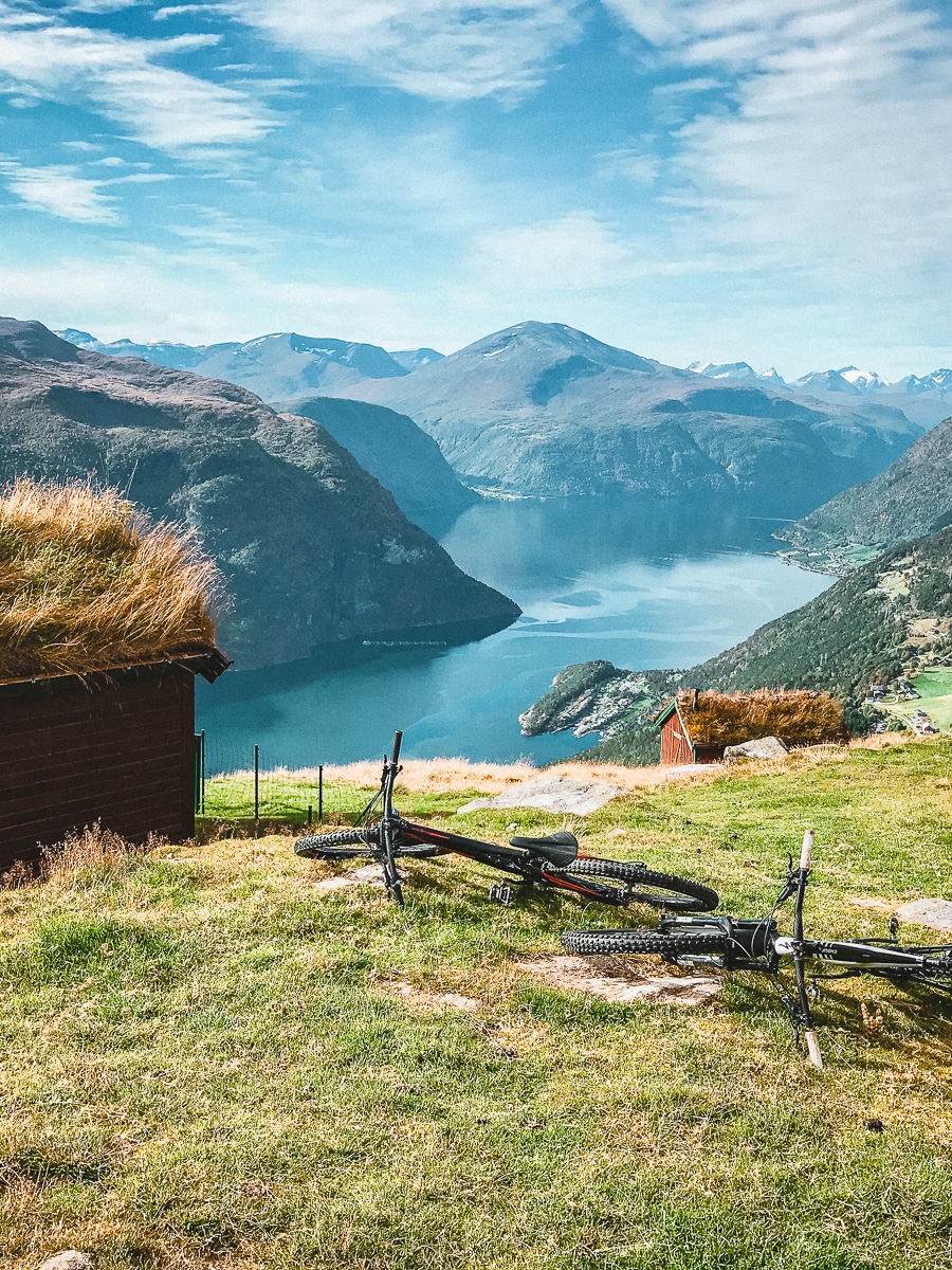
62°01'50" N · 7°16'37" EIf you can afford a sixth day, take it at Sande Camping on Lovatnet. The water is glacial turquoise; the Via Ferrata up Loen Skylift goes if you want vertical without the bike; the Skåla hike is a leg-burner with a hut at the top; and Hoven (Loen Skylift) gives you the view without the work. Some of the most contented hours you can have on a bike trip are off the bike entirely.
61°51'54" N · 6°51'00" EIf you want your shots to look the way these do, my Nordic Lightroom pack is the starting point I use on cold, blue-hour Norwegian light – the kind you get over Geirangerfjord and along the Strynefjellet road. Six presets, real RAW files behind every preview, 30-day refund. Optional – the guide stands on its own.
More of Norway, same treatment as this one. More on the way.