The wall
A first-hand guide to Western Norway's most photographed corner: Trollstigen's 11 hairpins, the Geirangerfjord, Lovatnet's turquoise glacier water, and the old Strynefjellet road in between. When to go, how long, where to base yourself, and the stops actually worth the detour.
Vestlandet is the western fjord region of Norway – the postcard one, where the mountains rise straight from the sea and the roads zig-zag up the walls. The compact triangle of Trollstigen, Geirangerfjord and Loen sits at its heart, and it's almost a self-closing loop: drive south from Åndalsnes over Trollstigen, take the Linge–Eidsdal ferry, climb Ørnevegen to Geiranger, cross Strynefjellet down to Loen, then sail back through the UNESCO fjord on the Hellesylt–Geiranger ferry to close the circle.
It's a road experience above anything else. The hairpins, the viewpoints, the waterfalls visible from your windscreen – this is what people come for. But the slow stops are what make the trip. Half an hour at Flydalsjuvet at dusk. A walk behind Storseterfossen. A swim in Lovatnet on a hot day. This guide is how I'd plan it for a first or second visit – the timing, the base, the route, and the stops that turn a drive into a trip.
4–5 days covers the triangle (Trollstigen, Geiranger, Loen) with time to slow down. A week opens up Skåla, Briksdalsbreen, and a detour into the Sunnmøre Alps. 3 days only works if you skip either Loen or the Strynefjellet road and treat it as a fly-by.
Don't pick one base for the loop – you'll burn the days driving back. Move bases: one or two nights in Valldal or Åndalsnes for Trollstigen, two in Geiranger for the fjord, one or two in Loen / Stryn for Lovatnet and Briksdalsbreen.
Rental car or motorhome, picked up at Molde, Ålesund or Ørsta-Volda airport. The loop hinges on two ferries: Linge–Eidsdal (every 30 min, all year) and Hellesylt–Geiranger (4× daily, May–Oct). Book Hellesylt–Geiranger ahead in July and August via Fjord1 – cruise traffic fills slots.
Mid-October to late April Trollstigen is closed and the Strynefjellet old road is buried under snow. The loop simply doesn't run in winter – the long detour through Sjøholt and Stordal makes it a different trip. If you're set on a winter visit, head to Ålesund and Sunnmøre Alps instead.
The stops below, pinned along the loop from Åndalsnes south over Trollstigen to Valldal, across the ferry to Geiranger, over Strynefjellet to Loen, and back via the Hellesylt fjord ferry. Drag to explore.
Vestlandet is one of the rare places where the road itself is the attraction. These three stretches – two listed as Norwegian Scenic Routes – are the spine of the loop.
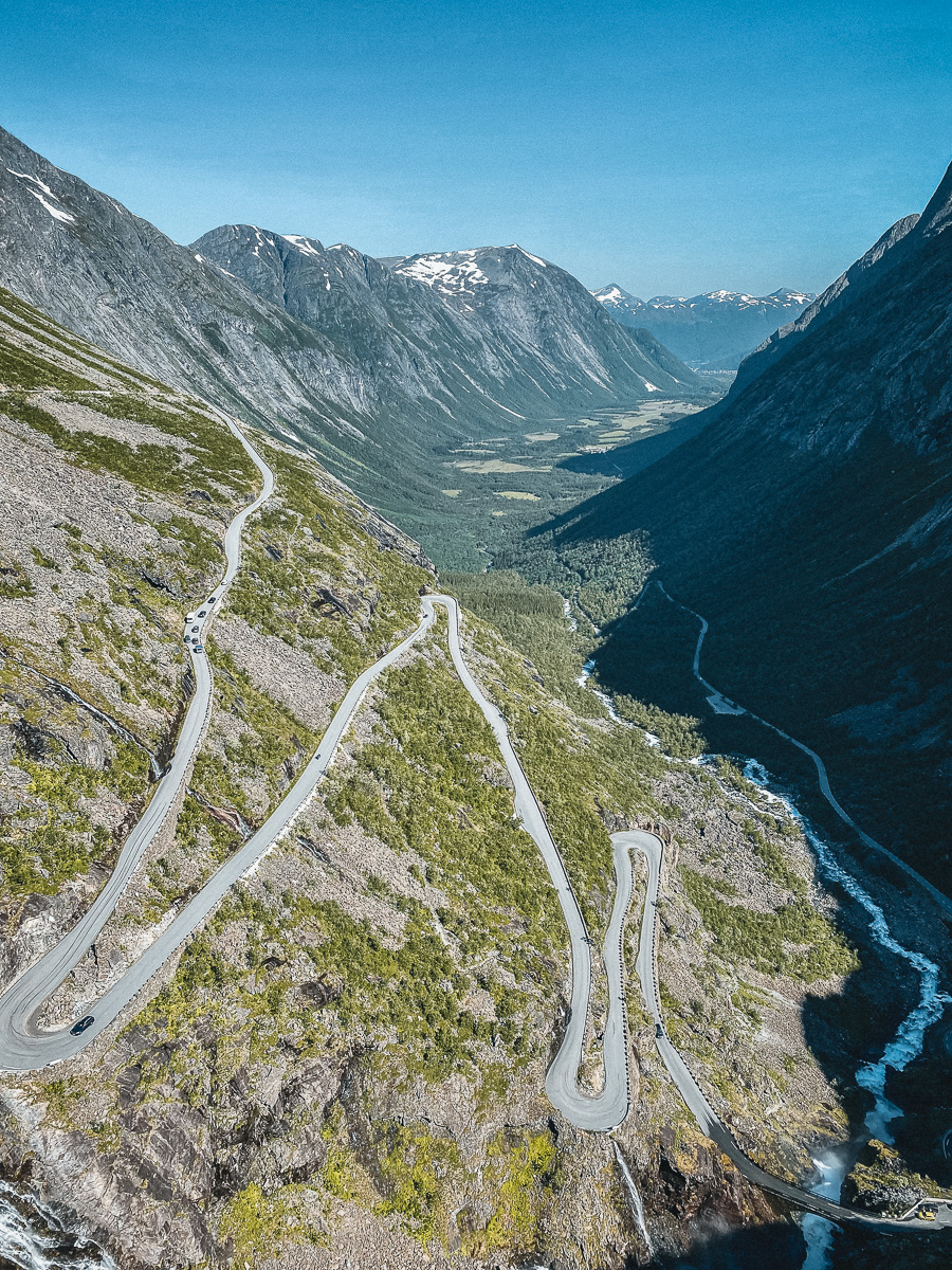
The road that defines Western Norway. Eleven hairpin bends climb the Isterdalen cliff face from Åndalsnes to a plateau 850 m up, where a cantilever platform hangs out over Stigfossen waterfall. Drive it from north (Åndalsnes) for the dramatic view up, from south (Valldal) for the gentler climb. Reopened in 2026 after the 2024 rockfall closure – conditions can change quickly, check Statens Vegvesen before setting off in shoulder season.
The southern half of the Geiranger–Trollstigen scenic route. From the Eidsdal ferry the road snakes up the headland, peaks at Korsmyra, then drops in a sequence of switchbacks toward Geiranger village with the fjord opening up in front of you. The descent into Geiranger is the better direction – do it in the afternoon when the light hits the western wall of the fjord.
The old Strynefjellet road, completed in 1894 and bypassed by the modern tunnel route. Narrow, partly gravel, lined by dry-stone walls and waterfalls, and almost free of traffic – it parallels the new Rv15 between Grotli and Videsæter and is one of the great undersung drives in Norway. Open roughly mid-May to mid-October. A campervan-width road only; not for a wide motorhome.
A mix of drive-up viewpoints and walks ranging from 15 minutes to a full hard day on Skåla. Times are one-way for a reasonably fit walker.
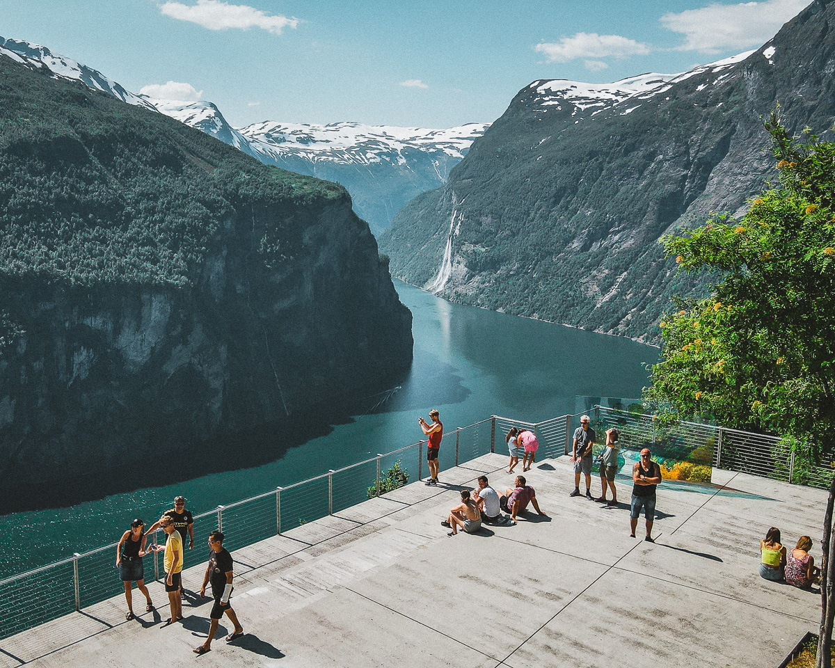
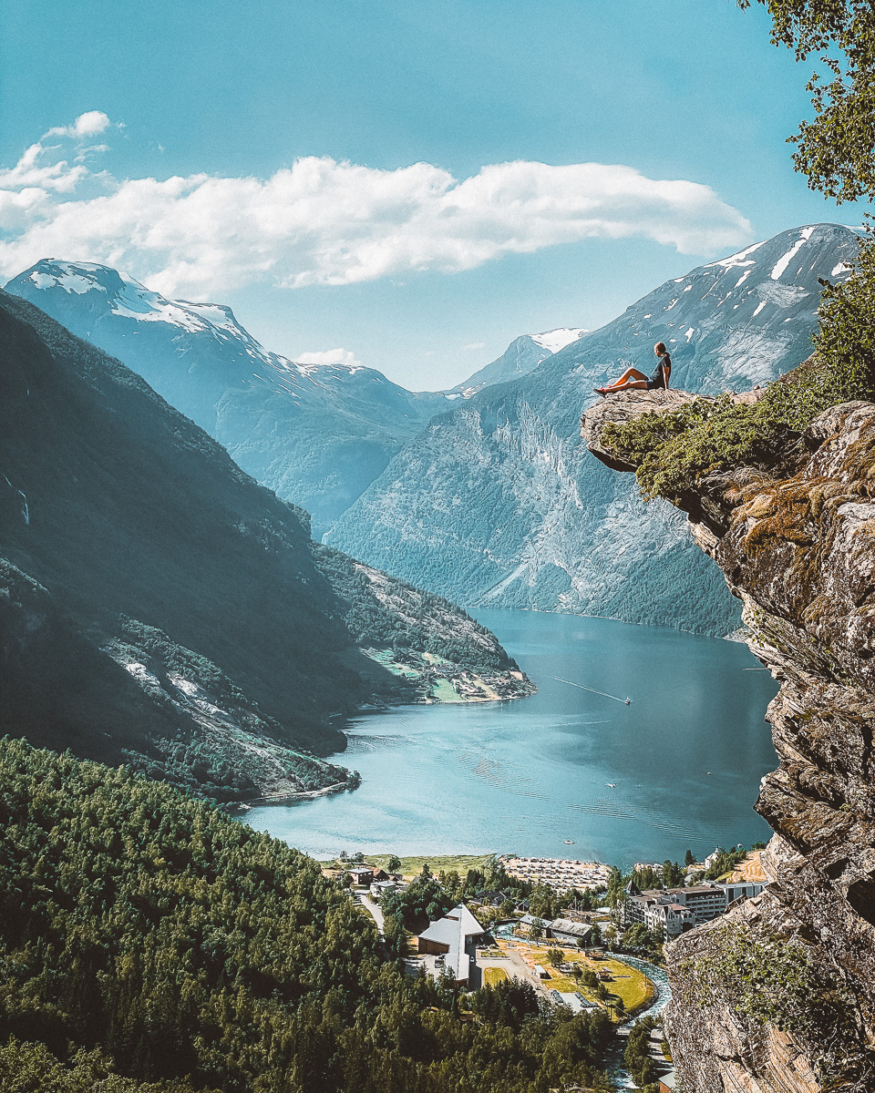
The classic Geirangerfjord postcard – the village below, the fjord curving away to the east, and a slab of rock everyone climbs onto for the photo. A short walk from the upper Flydalsjuvet car park on Fv63 above Geiranger. Go at sunrise or late evening to dodge the cruise crowds.
A 5 km toll road off Fv63 at Djupvasshytta climbs to a viewpoint at 1 476 m looking straight down on Geirangerfjord – the highest road-accessible view of the fjord. The platform was rebuilt in 2016 and it's worth the toll if the weather is clear. Closed when the road is snowbound (typically mid-October to late May).
One of the few waterfalls in Norway you can walk behind, and not a long hike either. Trail starts from Westerås farm above Geiranger – wood steps and packed earth up through birch forest to the curtain of water. Bring a waterproof; you'll get spray. Combine with lunch at Westerås.
One of the steepest cable cars in the world climbs from Loen to a panorama deck and restaurant at 1 011 m. Two ridge walks of 1–2 hours fan out from the top, including the Hoven viewpoint with the fjord, Lovatnet and the Jostedalen icefield all in one frame. Pricey, but a knee-saver and a clear-day must.
One of Norway's classic mountains: from sea level at Loen up to 1 848 m on Skåla, with a stone tower (Skålatårnet) on the summit you can sleep in. The trail is well-built but unrelenting. Pick a clear-weather day and start early. For most people it's a full day; some split it with a night in the tower.
Lovatnet at Loen is one of Norway's clearest glacier lakes – the colour is almost unreal in summer. Drive the dead-end road into Lodalen, swim or kayak from the gravel beaches, then continue on to Briksdalsbreen (a 25-minute drive from Olden): an easy walk up to a tongue of the Jostedalen glacier sliding down into a meltwater lake. Hire a Troll Car if you'd rather not walk back.
Three or four bases work for most trips. A few specific places I'd send friends to.
The hub of the loop. A small village squeezed between the mountains and the fjord, with the World Heritage centre, the ferry quay, and a clutch of restaurants and hotels. Stay two nights to absorb a full day on the fjord plus an evening at Flydalsjuvet. Cruise ships dock most summer days – go early or late for the village to itself.
The other natural overnight on the loop. Loen sits on the Nordfjord just past Stryn, with Lovatnet a few minutes inland and the Skylift gondola climbing straight from the village. Hotel Alexandra is the historic luxury option; Hotel Loenfjord and the campsites at Sande do the job for less. Stryn itself, 13 km west, has the supermarkets and the only Vinmonopolet for an hour in any direction.
Either side of the Trollstigen plateau. Valldal (officially Sylte) is the strawberry village at the bottom of the southern descent, with the Juvet Landscape Hotel a few minutes out the road – the building from Ex Machina, set above the river. Åndalsnes is the bigger town on the northern side, with the Rauma railway terminus, the Romsdalseggen ridge above it, and easier access to the Atlantic Road. Use one as a base for one or two nights either side of Trollstigen.
A small village built around a waterfall that runs through it. Mostly known as the western end of the Geirangerfjord ferry – an hour-long sail through the UNESCO fjord that closes the loop without retracing your route. Not really an overnight, but a worthwhile lunch stop before the ferry, with a campsite if you do need to overnight to catch the morning sailing.
For a once-in-a-lifetime night, Juvet Landscape Hotel above Valldal or Hotel Union Geiranger with the heated pool overlooking the fjord. For solid mid-range, Hotel Loenfjord in Loen and Storfjord Hotel outside Ålesund. For tent and campervan, Sande Camping at Lovatnet is the standout (and one of the cheapest big spends per night). Book everything indoors months ahead for July and August – cruise traffic to Geiranger fills hotels.
A loose plan if it's your first time. The loop works in either direction – this one puts Trollstigen on the most dramatic side (Åndalsnes-up) on day 1, and closes with the UNESCO fjord ferry. Shuffle around the weather; save Skåla or Dalsnibba for the clear day.
Fly into Molde or take the Rauma train into Åndalsnes. Stop at Trollveggen Besøkssenter for the look up Europe's tallest vertical rock face, then drive the eleven hairpins of Trollstigen and walk the cantilever platforms over Stigfossen. Descend into Valldal for the night – or splash out at Juvet.
Short morning to the Linge ferry, 13 minutes across to Eidsdal, then climb the Eagle's Road and drop into Geiranger. Spend the afternoon at Flydalsjuvet and walking up to Storseterfossen. Two nights in Geiranger if you can.
The slow day. Kayak from the village, take a smaller fjord sightseeing boat to the Seven Sisters, or hike up to Skageflå farm. Either back to Geiranger for a second night, or drive up to Dalsnibba viewpoint for a sunset over the fjord.
Climb out of Geiranger past Dalsnibba, over to Grotli, and drop down the old Strynefjellet road through hairpins and waterfalls. Lunch at Hjelle. Afternoon at Lovatnet – swim if it's hot – and Briksdalsbreen if there's time. Night in Loen.
Up the gondola at first opening, ridge walk above the cloud line if it's clear, back down for an early lunch. Drive to Hellesylt for the afternoon ferry through Geirangerfjord (the slow, beautiful way to see it). From Geiranger, retrace Ørnevegen and the Linge ferry back to Åndalsnes – or break the loop here and continue south to Sognefjord.
The same five-day route works on a bike from Åndalsnes, with 4 nights in tent at campsites along the way: Valldal, Geiranger, Sande Camping at Lovatnet, and back to Geiranger after the Hellesylt ferry. Total around 290 km and 3 200 m of climbing, with both sides of Trollstigen and the Strynefjellet old road. Pack proper waterproofs – the plateau gets sub-10°C even in July. Full day-by-day bike itinerary →
The famous viewpoints earn their fame, but the western fjords still hide quieter corners. Treat them gently. Tap the coordinates to open them in Maps, and leave them exactly as you found them.
One of Norway's narrowest valleys, threading between the Sunnmøre Alps from Hellesylt toward Øye and the Hjørundfjord. A submerged farm under Lygnstøylvatnet, alpine peaks crowding the road, almost no traffic. Drive it slowly – stop at the lake to look down through the water at the old buildings. A side detour from the Hellesylt area, well worth half a day.
62°9'50" N · 6°38'56" EFrom Linge, drop the Trollstigen-to-Geiranger script and turn east along Norddalsfjorden into Tafjord. A dead-end road, an abandoned hydroelectric village, the deepest fjord in the area, and a 1934 rockslide tsunami site you can read about in the small museum. Almost no tourists. A morning's detour, particularly worth it if Geiranger is full of cruise ships.
62°14'20" N · 7°25'23" EIf you want your shots to look the way these do, my Nordic Lightroom pack is the starting point I use on this kind of moody, high-contrast fjord light. Six presets, real RAW files behind every preview, 30-day refund. Optional – the guide stands on its own.
More of Norway, same treatment as this one. More on the way.